|
|
Post by lachinatown on Aug 27, 2018 12:12:50 GMT -5
jeremychin,
Yes, by the Tanjiang River. We were misled by the Doushan reference.
|
|
|
|
Post by abraham on Sept 3, 2018 1:24:47 GMT -5
Hello, I just came into contact with my father's second cousin. I have received some more information about the village- including the nearest town, I believe. 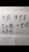 With regards to additional pictures, I am in the process of obtaining more photos. Abraham |
|
|
|
Post by lachinatown on Sept 3, 2018 9:35:51 GMT -5
Same as your village picture. This is written in traditional Chinese, whereas the sign in simplified Chinese. 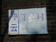 |
|
|
|
Post by abraham on Feb 6, 2020 0:18:35 GMT -5
Hello, Its been awhile. I rummaged awhile for these. I was told the first photo is a gateway to my family village or somewhere close to that. The second photo is the clearer view of faded writing on the ancestral hall. The third is a river/creek bend (I think) that runs by the village which my grandfather described to me. I hope these help. |
|
|
|
Post by jasonwu on Feb 6, 2020 13:39:45 GMT -5
Hi abraham,
Initially, I found it strange that the archway pictured had 南安大道 Nam On / Nan'an Road written across the top, but upon checking satellite maps, it all made sense.
By this point, it's quite clear that the village in question is called 江美 Kong May / Jiangmei near 沖雲墟 Chung Wan / Chongyun Market. However, to reach this village from the nearest highway, the driver must cross through the fields of other villages - the largest one being 南安 Nam On / Nan'an. So, it seems that the driver exited the highway through this village's road, 南安大道 Nam On / Nan'an Road.
In the image below, Nam On, its road archway, Kong May, and Chung Wan Market are marked. I could not, however, find the ancestral hall in the satellite imagery. The highway is seen in the lower left and the river that your aunt talked about is in the upper right. This is the Taicheng River that crosses through the county city of Toishan upstream and empties into the Tanjiang River downstream. There is also a stream that empties into the Taicheng River between Nam On and Kong May. Here is the Google Maps link to the same view: link here.
The source for the village locations is the official Chinese mapping website Tianditu.com.
Best, Jason
|
|
|
|
Post by tyuti1668 on Feb 6, 2020 17:17:37 GMT -5
... the official Chinese mapping website Tianditu.com... It should be map.tianditu.gov.cn/ ("gov" NOT com) |
|
|
|
Post by robert123 on May 15, 2020 4:19:04 GMT -5
Hi Tyuti & Jason, the map.tianditu.gov.cn/ online mapping app is excellent. I have been using a combination of Baidu Map, Mapbar and Google Maps. However this one beats all of them in terms of labelling of villages. For satellite imagery I been using satellites.pro satellites.pro/China_map#22.299336,112.716988,18 since I’ve often found their imagery much clearer. Their labelling, unfortunately, is almost non-existent. |
|
|
|
Post by jasonwu on May 15, 2020 18:35:32 GMT -5
Hi robert123,
Thanks for sharing! I agree, Tianditu is definitely one of the more accurate and detailed online mapping services, especially due it being developed by the State Bureau of Surveying and Mapping in China. However, the user cannot share a location via link as one would with Google Maps.
For satellite imagery, Google Earth Pro is excellent as well - there is also a feature to export high definition images straight from program. It, however, doesn't provide village tags just like satellites.pro which uses Apple imagery.
Best,
Jason
|
|


