|
|
Post by 1geewong on Jul 20, 2018 15:01:45 GMT -5
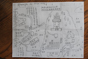 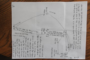 Hello, I think I have attached images from 2 hand-drawn maps of village names, locations and directions .... maybe more but I can read none of it. Can someone determine where these maps are in the modern world? In general from family history, this should be in Taishan, probably west of Taishan city proper Thank you for any ideas! |
|
|
|
Post by lachinatown on Jul 20, 2018 17:18:08 GMT -5
what do you mean? One in English. You can read that. lol.
The English version show Guangzhou at the top, and Taicheng (Taishan City) to the right.
The Chinese one shows the villages and roads in relation to LongAnLi village.
|
|
|
|
Post by 1geewong on Jul 21, 2018 6:21:13 GMT -5
Haha, well yes, much is in English but even that isn't easily convertable to modern understanding .... at least to someone as ignorant of the locations as myself.
So Taishan is labeled in English "Toy Cheng"?
Is LongAnLi village on the Chinese language map? If not, is there a relationship between the 2 maps? I thought they are directions to the same location with differing detail.
Is LongAnLi village the village with the building details that make up the right half of the drawing? Can you provide lat/long for LongAnLi village?
Thanks
|
|
|
|
Post by lachinatown on Jul 21, 2018 9:14:28 GMT -5
Because there was no standardization of romanization of Chinese, there are variations of English spelling.
That's why we keep asking people for Chinese characters.
Have we located the village for you on Google map already before?
The Chinese language map is all about LongAnLi, shows the building, wells, fields, "automobile" road etc. (some already have English on it, like the concrete bridge.)
The village gate is on the left.
When I have some time, maybe I can put the English to the Chinese map. It is very detailed map. Whoever did it was very good at drawing the map.
There are two Long An in that area. But I think I know which one is correct.
The English directional map showw the villages of the father and mother of the person who drew the map, not the same as LongAnLi. And the Chinese map was a detailed map of the village.
|
|
|
|
Post by 1geewong on Jul 21, 2018 13:55:05 GMT -5
Thanks for the help, Lachinatown
Yes, I have inquired about villages before but that was a different family line. Could be in the same general area.
Interesting. I don't know any specific significance to LongAnLi; I was thinking that was one of the home villages .... but apparently not. So what I'm actually interested in getting is a Lat/long (or some other traceable guidance) to the parental villages.
Thanks again
|
|
|
|
Post by lachinatown on Aug 1, 2018 19:18:57 GMT -5
Long An Li is located at approx. 22.204900, 112.596420. The road leading to the village is called LongAn Ave. per Google map.
The nearby villages mentioned on the detail map are: Zhao yang li, si ja, hui long li.
|
|
|
|
Post by lachinatown on Aug 3, 2018 10:39:01 GMT -5
As for the direction map (best guesses due to same names):
Guangzhou, Guangdong, 23.126174, 113.262316
Taishan (Toy Cheng as written on your map) 22.254805, 112.792650
XinChang (ShinChang) 22.360520, 112.699406
Changjiang (ChongKong)22.243266, 112.638906
Baisha (BarShaw) 22.246726, 112.599896
BeiKeng(BarkHung) 22.294681, 112.787050
Hengshui(WongShui) 22.211465, 112.632662
Note: map orientation may not have drawn correctly.
|
|
|
|
Post by 1geewong on Aug 5, 2018 9:05:15 GMT -5
THANKS!!! Lachinatown
|
|


